


Lac d’embouilleu

RvGuib35
User
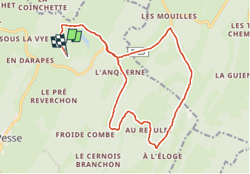

Length
11.3 km

Max alt
1338 m

Uphill gradient
323 m
Km-Effort
15.6 km

Min alt
1118 m

Downhill gradient
315 m
Boucle
Yes
Creation date :
2024-07-03 07:49:41.0
Updated on :
2024-07-03 10:53:19.785
3h02
Difficulty : Easy

FREE GPS app for hiking
 SityTrail
IGN / Geographical institutes
SityTrail Plus
The world is yours!
About
Trail Walking of 11.3 km to be discovered at Bourgogne-Franche-Comté, Jura, La Pesse. This trail is proposed by RvGuib35.
Positioning
Country:
France
Region :
Bourgogne-Franche-Comté
Department/Province :
Jura
Municipality :
La Pesse
Location:
Unknown
Start:(Dec)
Start:(UTM)
720466 ; 5131351 (31T) N.
Comments